
the Mayfield Point
(photo by Brad Mayfield)
As with many towns I'm sure, here around Lafayette, Louisiana we use the term “Old Lafayette” to describe present-day folks who embody the best qualities that our town is traditionally known for, which for Lafayette includes things like a dogged cheerfulness about life – even in adversity, a tolerance for others, a perpetual readiness to help others be they strangers or kin; and lastly, a perpetual readiness to celebrate – which here means we know how to cook the best kind of stuff, make the best kind of music, and dance the best kind of dances – summarized by an oft-heard Old Lafayette saying, “We know what's good, chere!” In these days of fear and the paranoid reality that it tends to create, “Old Lafayette encounters have become more than a breath of fresh air; more like a much-needed shot of oxygen. But I digress . . .
Anyway, imagine, then, the faces of the two eleven-year-old playmates who happened to stumble across a tool used right in their “Old Lafayette” backyard – only the tool's owner's “Old Lafayette” existed 10,000-12,000 years ago. Uh-huh. Now that's Old Lafayette, ya'll.

The Mayfield Backyard; Bayou Vermilion Flowing in Background
(photo by Brad Mayfield)
That's precisely what happened to Jenny Mayfield and Tammy Byers back in the spring of 1974 in Jenny's backyard along the Bayou Vermilion. Bending down to look at the washed-over roots of an old hickory tree, Tammy found a Clovis point; a spearhead used by North America's first human inhabitants who arrived in “Lafayette” back at the end of the Ice Age.
Excitedly, they rushed rushed in the house hollering for Jenny's dad, Ben, to see it. “Duly impressed,” as Jenny put it, Ben followed the girls out to the spot where they had found it. According to Ben, he could see “its resting place was very clearly marked by a sunken impression, surrounded by a layer of moss and dirt, on top of a large root.”

Halfway Down the Bluff, 10-12,000 year-old Red River Strata is Exposed
(photo by Brad Mayfield)
The Mayfield house sits on a twenty-five-foot bluff overlooking the Vermilion Bayou, which widens to more of a river as it flows through southern Lafayette en route to its terminus in Vermilion Bay. Ben said the spearpoint was located at a place of an abrupt change in slope, which probably marks the “second bottom” of the bayou – the point to which floodwaters swell on a seasonal basis.
Oddly, Ben Mayfield mentions that the original hickory tree where the girls found the spearpoint was toppled by Hurricane Lily in 2004, at which time he aged the tree via ring-count. It was only 100 years old! So, this tree, as a chance-seedling happened germinate near the Clovis point, eventually bringing it up with its roots? That's what it sounds like, as I can't imagine flowing floodwaters powerful enough to carry that spearhead very far. Bayou Vermilion's flow is flat/wide/slow – even in the floodiest of times.
Ben further states that the spearpoint was found in a soil strata of “ochre-colored clay,” correlating to a time when the ancient/Pleistocene Red River ran through the course taken by present-day Bayou Vermilion.
Keep in mind that at different times during the Pleistocene/Holocene periods (1,000,000 – 5,000 years B.P.), both the ancient Red and Mississippi Rivers ran through the present-day channels of the Atchafalaya River, Bayous Teche and Vermilion, and westward across the Mermentau River Basin and into the Calcasieu and Sabine River system at the Louisiana-Texas border.
The Pleistocene, known as the “Ice Age,” was actually comprised of about ten successive 100,00-year Ice Age cycles whereby the Arctic Circle would basically migrate south into the present-day northern U.S., tying up massive amounts of water into ice and causing sea level to drop 100-300' .
These periods of glaciation were followed by interglacial periods whereby the ice to our north would melt, creating equally massive rivers of meltwater coursing southward into the Gulf of Mexico. These ancient rivers shifted around with each successive interglacial period, acting like bulldozers in pushing rock, sand, and mud southward and then wiggling east-west like the end of an untended hose, fanning the sediment to create our present-day river deltas.
It is said that at the very end of the Pleistoncene and beginning of the Holocene – about 5,000 years ago – the Mississippi River was flowing right here through south-central Louisiana. Its western bank was what we know today as the “Coteau Ridge” in St. Landry and Lafayette parishes, and the “Terrace” (pron. "Teh-ROSS" roll that "r" ya'll . . .) further south in St. Martin and Iberia parishes. At that time, it was carrying nineteen times the volume of water compared to the present-day flow of the Mississippi River.
By the early 1990s, local archeologist Thomas Marckese had gotten wind of the Mayfield Point, and wrote it up in Volume 19 No. 3 of the Louisiana Archeological Society Newsletter. In his paper, Marckese provides very good background to the Clovis People story in Louisiana. Keep in mind that Louisiana's oldest known Native American settlement is at Poverty Point in the extreme northeastern portion of the state. That site dates back about 1,000 years, and is considered among the oldest Native American settlements in the U.S. Contrast that fact with the Clovis period, which dates back 11,950-10,770 years B.P., according to Marckese.
Wanna talk about old? These folks were so “old” that they didn't make pottery -- hadn't been invented yet in this neck of the woods -- and lived many thousands of years before even the bow and arrow were conceived. They had no true settlements. They were nomads, chasing big mammals like mammoth, ground sloth, camel, and bison down with spears, which they threw with the aid of an atlatl or throwing stick. In the New World, Clovis point finds have been found from the Great Lakes southward through Central and South America to Equador.
In his paper Marckese mentions that the Mayfield Point is constructed from a fine, “waxy” grey flint, probably originating in present-day central Texas. Conventional archeology believes that locally, Clovis people headquartered there, probably following bison herds into present-day Louisiana on a seasonal basis. Marckese mentioned additional Clovis finds in Louisiana, stretching diagonally from northwestern Louisiana southeastward into south-central Louisiana, with local finds from Lawtell and Grand Coteau, (St. Landry parish), the present-day Lafayette airport (Lafayette parish), down on Cote Blanche Island (Iberia parish) – and now the Mayfield backyard in Lafayette – forming a line along the ancient Red River as it coursed all the way south into the Gulf of Mexico at the end of the Pleistocene.
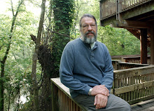
The Louisiana Coast ca. 18,000(?) Years Ago
Pardon the Red Marks...
In this map that I lifted from Atlas of Louisiana – A Guide for Students (Milton Newton, Jr. 1972), you see a depiction of the shoreline of present-day “Louisiana” at some point toward the end of the Pleistocene (for some reason, 18,000 B.P. Sticks in my mind, though I can't find the actual date). Note how far past our present-day shoreline it goes, creeping well onto the continental shelf. Note the depiction of rivers corresponding to 150-mile southward extensions of our present day Teche, Vermilion, Mermentau, Calcasieu, and Sabine river systems.
And what of the terrain of all this additionally exposed late-Pleistoncene land? Not forested, but rather cool/moist prairie – similar to what we see through much of central and western Canada today. So Real Old Lafayette is where the buffalo once roamed – and mammoths, and giant ground sloths, and camels . . . and Clovis people. As Marckese stated, present-day south-central Louisiana, being the late-Pleistocene recipient of massive amounts of northern meltwater and sediment, made for a very fertile and diverse biotic community – certainly attractive then, in both climate and ecology, to early human hunters.
Turns out that Lafayette has been a happening place at least 218 centuries before the first Frenchman ever set foot here with his black iron pot and fiddle. . .

It's pretty cool to find a piont like that and realize that we're living in the same area as the ancients. Wasn't the forest around Proverty Point a hardwood jungle? Home to the ivory-billed woodpecker and other wonderful critters.
ReplyDeleteWhat a find! Absolutely beautiful condition. I can't believe that was found right in our old stomping grounds!
ReplyDeleteThe oldest site in Louisiana is at Watson Brake SW of Monroe. It is centuries older than Poverty Point.
ReplyDelete