Wednesday, February 23, 2011

real old lafayette

the Mayfield Point
(photo by Brad Mayfield)


As with many towns I'm sure, here around Lafayette, Louisiana we use the term “Old Lafayette” to describe present-day folks who embody the best qualities that our town is traditionally known for, which for Lafayette includes things like a dogged cheerfulness about life – even in adversity, a tolerance for others, a perpetual readiness to help others be they strangers or kin; and lastly, a perpetual readiness to celebrate – which here means we know how to cook the best kind of stuff, make the best kind of music, and dance the best kind of dances – summarized by an oft-heard Old Lafayette saying, “We know what's good, chere!”


In these days of fear and the paranoid reality that it tends to create, “Old Lafayette encounters have become more than a breath of fresh air; more like a much-needed shot of oxygen. But I digress . . .

Anyway, imagine, then, the faces of the two eleven-year-old playmates who happened to stumble across a tool used right in their “Old Lafayette” backyard – only the tool's owner's “Old Lafayette” existed 10,000-12,000 years ago. Uh-huh. Now that's Old Lafayette, ya'll.


The Mayfield Backyard; Bayou Vermilion Flowing in Background
(photo by Brad Mayfield)


That's precisely what happened to Jenny Mayfield and Tammy Byers back in the spring of 1974 in Jenny's backyard along the Bayou Vermilion. Bending down to look at the washed-over roots of an old hickory tree, Tammy found a Clovis point; a spearhead used by North America's first human inhabitants who arrived in “Lafayette” back at the end of the Ice Age.

Excitedly, they rushed rushed in the house hollering for Jenny's dad, Ben, to see it. “Duly impressed,” as Jenny put it, Ben followed the girls out to the spot where they had found it. According to Ben, he could see “its resting place was very clearly marked by a sunken impression, surrounded by a layer of moss and dirt, on top of a large root.”


Halfway Down the Bluff, 10-12,000 year-old Red River Strata is Exposed
(photo by Brad Mayfield)


The Mayfield house sits on a twenty-five-foot bluff overlooking the Vermilion Bayou, which widens to more of a river as it flows through southern Lafayette en route to its terminus in Vermilion Bay. Ben said the spearpoint was located at a place of an abrupt change in slope, which probably marks the “second bottom” of the bayou – the point to which floodwaters swell on a seasonal basis.

Oddly, Ben Mayfield mentions that the original hickory tree where the girls found the spearpoint was toppled by Hurricane Lily in 2004, at which time he aged the tree via ring-count. It was only 100 years old! So, this tree, as a chance-seedling happened germinate near the Clovis point, eventually bringing it up with its roots? That's what it sounds like, as I can't imagine flowing floodwaters powerful enough to carry that spearhead very far. Bayou Vermilion's flow is flat/wide/slow – even in the floodiest of times.

Ben further states that the spearpoint was found in a soil strata of “ochre-colored clay,” correlating to a time when the ancient/Pleistocene Red River ran through the course taken by present-day Bayou Vermilion.

Keep in mind that at different times during the Pleistocene/Holocene periods (1,000,000 – 5,000 years B.P.), both the ancient Red and Mississippi Rivers ran through the present-day channels of the Atchafalaya River, Bayous Teche and Vermilion, and westward across the Mermentau River Basin and into the Calcasieu and Sabine River system at the Louisiana-Texas border.

The Pleistocene, known as the “Ice Age,” was actually comprised of about ten successive 100,00-year Ice Age cycles whereby the Arctic Circle would basically migrate south into the present-day northern U.S., tying up massive amounts of water into ice and causing sea level to drop 100-300' .

These periods of glaciation were followed by interglacial periods whereby the ice to our north would melt, creating equally massive rivers of meltwater coursing southward into the Gulf of Mexico. These ancient rivers shifted around with each successive interglacial period, acting like bulldozers in pushing rock, sand, and mud southward and then wiggling east-west like the end of an untended hose, fanning the sediment to create our present-day river deltas.

It is said that at the very end of the Pleistoncene and beginning of the Holocene – about 5,000 years ago – the Mississippi River was flowing right here through south-central Louisiana. Its western bank was what we know today as the “Coteau Ridge” in St. Landry and Lafayette parishes, and the “Terrace” (pron. "Teh-ROSS" roll that "r" ya'll . . .) further south in St. Martin and Iberia parishes. At that time, it was carrying nineteen times the volume of water compared to the present-day flow of the Mississippi River.

By the early 1990s, local archeologist Thomas Marckese had gotten wind of the Mayfield Point, and wrote it up in Volume 19 No. 3 of the Louisiana Archeological Society Newsletter. In his paper, Marckese provides very good background to the Clovis People story in Louisiana. Keep in mind that Louisiana's oldest known Native American settlement is at Poverty Point in the extreme northeastern portion of the state. That site dates back about 1,000 years, and is considered among the oldest Native American settlements in the U.S. Contrast that fact with the Clovis period, which dates back 11,950-10,770 years B.P., according to Marckese.

Wanna talk about old? These folks were so “old” that they didn't make pottery -- hadn't been invented yet in this neck of the woods -- and lived many thousands of years before even the bow and arrow were conceived. They had no true settlements. They were nomads, chasing big mammals like mammoth, ground sloth, camel, and bison down with spears, which they threw with the aid of an atlatl or throwing stick. In the New World, Clovis point finds have been found from the Great Lakes southward through Central and South America to Equador.

In his paper Marckese mentions that the Mayfield Point is constructed from a fine, “waxy” grey flint, probably originating in present-day central Texas. Conventional archeology believes that locally, Clovis people headquartered there, probably following bison herds into present-day Louisiana on a seasonal basis. Marckese mentioned additional Clovis finds in Louisiana, stretching diagonally from northwestern Louisiana southeastward into south-central Louisiana, with local finds from Lawtell and Grand Coteau, (St. Landry parish), the present-day Lafayette airport (Lafayette parish), down on Cote Blanche Island (Iberia parish) – and now the Mayfield backyard in Lafayette – forming a line along the ancient Red River as it coursed all the way south into the Gulf of Mexico at the end of the Pleistocene.
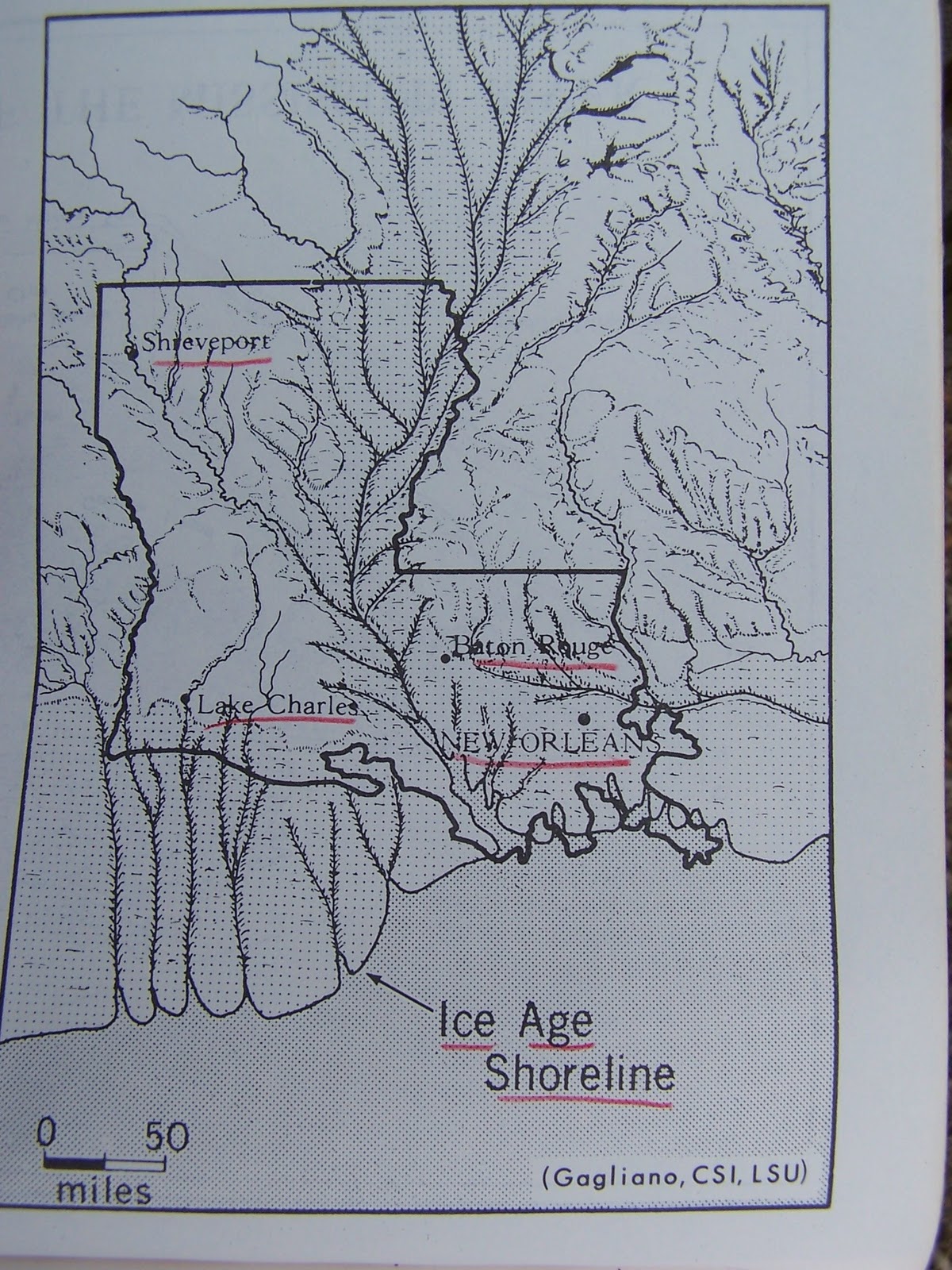
The Louisiana Coast ca. 18,000(?) Years Ago
Pardon the Red Marks...

In this map that I lifted from Atlas of Louisiana – A Guide for Students (Milton Newton, Jr. 1972), you see a depiction of the shoreline of present-day “Louisiana” at some point toward the end of the Pleistocene (for some reason, 18,000 B.P. Sticks in my mind, though I can't find the actual date). Note how far past our present-day shoreline it goes, creeping well onto the continental shelf. Note the depiction of rivers corresponding to 150-mile southward extensions of our present day Teche, Vermilion, Mermentau, Calcasieu, and Sabine river systems.

And what of the terrain of all this additionally exposed late-Pleistoncene land? Not forested, but rather cool/moist prairie – similar to what we see through much of central and western Canada today. So Real Old Lafayette is where the buffalo once roamed – and mammoths, and giant ground sloths, and camels . . . and Clovis people. As Marckese stated, present-day south-central Louisiana, being the late-Pleistocene recipient of massive amounts of northern meltwater and sediment, made for a very fertile and diverse biotic community – certainly attractive then, in both climate and ecology, to early human hunters.

Turns out that Lafayette has been a happening place at least 218 centuries before the first Frenchman ever set foot here with his black iron pot and fiddle. . .

Friday, February 11, 2011

more on "salt birds"


sunset over Louisiana's outer continental shelf
(photo by Edward Watson)

“People” said that my last post ('sittin' in the pass of the bay') ended too abruptly. Probably so. I just 1) didn't have anything more to say on the subject at the time, and 2) am still reveling at the “look ma no editor” aspect of blogging. It is a refreshing thing, especially for those who write for a living....


Anyway, Dave Patton recently sent me a coupla more offshore bird photos; and Edward Watson sent in a beaut as well....all of which inspired this post.


Ring-billed Gulls....one of Louisiana's most common winter seabird species

Whenever you go out on a boat in the Gulf of Mexico with Dave Patton, there's an unspoken promise that you'll eventually end up chumming for seabirds. For many years, very little was known about Louisiana's offshore seabird population. It was a simple case of too few ornithologically-inclined people going offshore. Prior to 1970, biologist Jake Valentine (what a name, what a guy) was among the “too few” going out to do census work. By the mid-1970s, regular survey work began throughout the state's coastal barrier island system; and by the 1990s quasi-regular, far-offshore survey trips were happening.


big ol' barrel-chested Pomarine Jaeger (i think)
([unidentified] photo by Dave Patton)

Closer in to shore, several easy-to-view-but-rarely-viewed bird species spend substantial amounts of time along the Louisiana coast. Of these, Dave likes to look for the Jaegers best. “Jaeger” is German for “hunter”........ but perhaps “Meisterdieb” (German for “master thief”) would be a better name for these birds. Gull-like in most aspects, the Jaegers posses a swifter, more falcon-like flight style, which they use to great advantage in committing regular mid-air robberies of fish-laden gulls and terns. It's not like Jaegers steal food on occasion; that's what they do for a living.


Parasitic Jaeger
(photo by Dave Patton)

Three species of Jaeger are native to North America: Long-tailed Jaeger, Parasitic Jaeger, and Pomarine Jaeger. All of them nest up in the Arctic Circle, and all of them can be occasionally spotted throughout larger lakes and reserviors over most of the U.S. during fall/winter/spring migration periods. The best places to find them, though, are the nearshore waters of the Atlantic, Pacific, and Gulf of Mexico.


young Black-legged Kittiwake wheels toward the chum
(Photo by Dave Patton)

The Black-legged Kittiwake is another far-north breeder that turns up throughout most of the U.S. during migration periods. I use the term “turns up,” but in truth relatively few observers get to record Kittiwakes and/or Jaegers in the lower 48. Percentage-wise, the odds of running across one of these species during migration are substantially low.... unless you 1) own a boat or happen to know someone who owns a boat, 2) have a pretty good idea of what you're looking for, when to look for it, and where to look for it.

Here in Louisiana, that translates to nearshore Gulf waters, fall/winter/spring, with Dave Patton. And don't forget your fishin' pole.

Thursday, January 27, 2011

sittin' in the pass of the bay


Hooded Mergansers -- gorgeous fish-eating ducks -- at Southwest Pass

January 26 dawned at a chilly (for us) 34F and a light north wind; but by the time we reached the Cypremort Point boat launch a couple of hours later, it had warmed considerably and it was nearly dead calm. The wind didn't know which way to blow.


Dave Patton and I have been watching birds together for about 25 years. By now, there ain't no more secrets to tell, so we mainly just enjoy each other's company. We don't get together as much as we used to, but we both hope that'll change soon. In fact, we're trying to do something about that today.

“More fishing” is definitely on my bucket list these days; and thanx to the influence of a mutual birding friend, Dave's thinking that way too. Dave's got a nice boat.

So he called me on the 25th wondering if i'd care to go fishing/birding down in Vermilion Bay. Oh yeah.

First thing, we putt through Shark Island and up to Mud Point and the infamous fishing hotspot called “the Trash Pile” in neaby Weeks Bay. My buddy Mark Manuel recently gave me a fine redfish/speckled trout rod that he built, and I went out and bought a cheap reel for it. I was hot to try it out, and the Trash Pile would be the perfect spot.

Dave's cleverly-constructed "leg block"... note matching paint job


Dave, on the other hand, had recently constructed a “leg shield” for his boat: a contraption devised to block the wind from coming in down under the windshield on his open-bowed bay boat.

We tested away and were happy with the results. But, alas, Weeks Bay was so damn birdless (and fishless) that it threatened to depress us both – on a perfectly beautiful day to be out on the water, no less. So by noon or so we're heading back east toward Cypremort Point and Dave's looking longingly at Vermilion Bay, to our south. To our amazement, the water was totally slick – smooth as glass – like some sort of glacial lake up in Canada, you know? Rarely does one get a chance to boat in such conditions along our coast. So Dave asks me if I felt like a ride to Southwest Pass – a 12 mile ride down to the foot of Vermilion Bay. I look at the water and go “yeah!”

The lower end of Vermilion Bay is blocked off from the Gulf of Mexico by Marsh Island. Marsh Island, a large barrier island, is aproned to the south and west with oyster reefs – miles of 'em. South of there, it's open Gulf.

Strange thing is that Vermilion Bay, like most bays in coastal Louisiana, probably averages no more than 5-feet in depth; and the open Gulf of Mexico to the immediate south of Marsh Island is proabably no more than 8-12-feet in depth. But the narrow cut between Marsh Island and the mainland of Vermilion parish – a cut known as Southwest Pass – is some 70-feet deep(!), literally carved through solid oyster reef via 10,000 years of strong tidal action between Vermilion Bay and the Gulf of Mexico.

En route to the pass, we decided that we ought to put in some Louisiana Winter Bird Atlas time in there, since the atlas season was on, and virtually no one birded Hellhole Bayou, the quad that contains Southwest Pass. Hellhole Bayou was data-starved, and we intended to rectify the situation.

Brown Pelicans sliding home....Safe!.....while the other team (American White Pelicans) yawns in astonishment.

Reaching Southwest Pass by about 1pm, we saw quite a few cormorants, pelicans, ducks, shorebirds, and what-have-you lolly-gagging around, on, and behind the reefs on both sides of the pass. Dave cut the engine, and we were immediately engulfed in this warm, sunny, near-perfectly calm setting.


The Scene....were it not for the bits of exposed reef, birds, etc., would you know which way was up?

 So nearly identical were sky and sea in color, texture, and temprement that all seemed to coalesce into One, leaving us with the feeling of being eerily suspended somewhere Within.


Suspended Somewhere Within...with my new pole/reel...i didn't know which way to throw it at the time.....As Captain Beefheart once exclaimed, "Do it start at the bottom, or do it start at the top?"

It's a hard thing to describe, I know; but certainly worth reporting. In fact, the only other time I've had that feeling was with Dave, on a Christmas Bird Count at Lacassine-Thornwell there in southern Jeff Davis parish. That day, it was the fog that disoriented – or more properly, misoriented us. That day, the heavily overcast sky merged with the fog and with the shallow water of a ricefield that stretched out before us for a half-mile or so. Suddenly we felt like we were floating somewhere Within. I remember the only way that I could gain some semblance of orientation was to look straight down at my feet anchored to the gravel road below....and even that short of a space was foggy!

Counting Green-winged Teal and Black-bellied Plovers behind a distant reef.
Necessity = Mutha of Invention

So calm was Southwest Pass that we found we could even operate a spotting scope from the boat! Of course we had earlier talked ourselves out of bringing along a tripod, reasoning that only an idiot would even attempt to scope birds from a pitching boat. But Dave did manage to bring his spotting scope in his camera bag, and necessity being the mutha of invention and all, we rigged an acceptable spotting scope mount using Dave's handy-dandy “leg-shield” anchored with bungie-cord onto his boat's bow rail.

Friday, December 31, 2010

'tis the season to be counting . . .

Snow Geese Under Half-Moon near Mire, LA
(Photo by Denny Culbert)

     Throughout the U.S., Canada, and parts of the Carribean, Christmas Bird Counts (CBC) have been run for over a century. Google “Christmas Bird Count” for historical details. Each year, the CBC season runs from December 18 - January 4. Well over 2,000 counts are run each season, including over 20 within the state of Louisiana.


Tallying every bird seen/heard Throughout the Day
is the worst part of a CBC
(photo by Denny Culbert)

 
     Individual count organizers select one day within the season to run a given count. Basically, 15 mile-diameter “count circles” are strategically selected, in which count compilers attempt to include as diverse of a line-up of different habitat types as possible. Then, participants are recruited, and the count circle is divided up in accordance with the number of observers participating. From pre-dawn to post-dusk, participants count every bird that they see and/or hear. At the end of the day, particpants meet to compare notes, and the count list is compiled.


Chris Brantley, Patti Hollard, Walker Wilson, Heather Mancuso
Working a Rice Field in Niblett (southwestern Jeff Davis Parish)

 
     The “Lac-Thorn” CBC was held on December 18 this year – a dry, cold, windy affair. Weatherwise, you never know what you'll get at a CBC. Last year, Lac-Thorn was so wet we couldn't even make it to Bayou Lacassine – the western terminus of our “Niblett” area, a complex of rice fields, pocket-marshes, and wooded canals, bayous, lakes, and small woodlots located northwest of the intersection of LA 14 and LA 99 in extreme southwestern Jeff Davis parish.

     Ditto for this year's Lafayette CBC held on December 28 – dry, cold, and breezy. Birding all bundled up and eyes watering from frigid winds is a challenge in itself. Our area in the Lafayette circle is way up on the northwestern edge, above I-10 around the rural communities of Mire, Vatican, and Ossun. Like our “Niblett” area at Lac-Thorn, the Mire/Vatican/Ossun landscape is primarily flat and open, but dominated by cattle pastures and only pocked with rice-fields and wooded ponds.


Coming in for a dawn Landing at Mire Crawfish Ponds
28F, Sick East Wind.....Brrrrrrrrrr
Patti's already got her hat on
   

Bill Vermillion Attempts to Stay Warm, Working the Mire Crawfish Ponds
(photo by Denny Culbert)
   

An Open-country Bird, the Killdeer can Take it Wet or Dry
(photo by Denny Culbert)

A Tree Swallow Plies the Frigid Air Above a Mire Crawfish Pond
What in the World can he be Finding to Eat in 28F Weather?!!???
(photo by Denny Culbert)

     In both circles, it was so dry this year that most of the rice fields were waterless; so we were at an immediate disadvantage regarding waterfowl, rails, shorebirds, and other water birds. Fortunately, a few fields remained "pumped up" for crawfish production. On both counts, the wind was so steady and chilly that most of the songbirds were laying low for much of the day.


Bless Their Lil' Hearts...Regardless of Weather Conditions,
You Can Always Count on Counting Chickadees.
They Wouldn't Miss a CBC for the World....
(photo by Denny Culbert)

  It wasn't until after lunch that the sun began to peek through the clouds, allowing a few warblers, sparrows, and others to slip up on exposed perches to catch a few rays. Still, the action was heavy, if not always fast and furious. We stayed pretty busy all day long at both places.


Good Things Come to Those who Work their Butts Off
We found this rare Ash-throated Flycatcher at a Very
Secluded wooded Lake near Mire, LA
(photo by Denny Culbert)


Patti Holland and Bill Fontenot Eye an Unidentified Hawk
In Low Light A Thousand or so Yards Away....Ah, Dawn.....

 
      Dawn is the crucial time for a CBC. Participants need to find a dawn-watch site that is as elevated (definitely a relative term here in south Lousiana) as possible, and that allows for the widest field-of-view. The dawn-watch site should also be located in or at least adjacent to as diverse a variety of habitats as possible, with “big water” being the most important ingredient. For me, as I'm sure is true for other experienced CBC participants, a successful dawn-watch (generally 6:30-9:00 a.m.) accounts for well over half of the total bird species listed for the day.


White Ibis, Cruisin' for Crawfish at Mire
(photo by Denny Culbert)

     Ducks, geese, herons, egrets, ibis, hawks, blackbirds, and other groups are commuting from roosting sites to feeding sites (or vice-versa) at this time. And once the sun rises, sparrows and other songbirds climb up to exposed perches to dry off their plumage, and soak up some warmth.


Here Comes the Sun, Little Darlin'....
A Swamp Sparrow Shaking off Dew at Mire
(photo by Denny Culbert)

     Each dawn-watch holds its own surprises. Just after dawn but prior to actual sunrise this year at Lac-Thorn, our Niblett group was treated to a close-up show featuring a female-type Peregrine Falcon riding a stiff northerly breeze only several feet above a rice field, playfully harassing three Great Egrets who were attempting to get a little breakfast in at a protected corner of the field.


Returning from a Successful "Owl Roost Run" in Niblett

 
     After dawn-watch, it's a matter of hunting and pecking, seeking out pockets of good-looking habitat that have the best potential for holding birds. This hunt and peck operation continues through the day.


A "Pocket Marsh" at Niblett

Patti Holland and Molly Richard Scour an Isolated Lake in Niblett
Their efforts were Rewarded with a Black-bellied Whistling Duck, Neotrop Cormorant, and Anhinga

      By mid-afternoon, the group begins to inventory potential sites for dusk-watch. As with the dawn-watch, a good dusk-watch spot needs to be elevated, and possess wide-open vista-like views – again, preferably adjacent to water. A successful dusk-watch can add several last-minute species that are generally not found at any other time, including selected duck, sandpiper, and owl species, Black-crowned Night-heron, Woodcock, and the like.

Dusk at Niblett
Molly "Taco Sister" Richard, Bill Fontenot, Patti Holland
(photo by Chris Brantley)
 
Niblett Dusk-watch Worked to Perfection, Nabbing
Six Black-crowned Night Herons and Two Short-eared Owls
 
     This year, funky weather conditons resulted in far fewer individual birds counted; plus total misses of numerous species which we ordinarly would tally without much trouble. Still, we did a respectable job at both counts, amassing a species list of 77 at Lafayette and 114(!) at Lac-Thorn. I've gotta say, the Niblett area of Lac-Thorn is about as birdy as it gets in Louisiana – not only from a species diversity perspective, but also from a sheer “biomass” perspective – like hundreds of gulls, tens of thousands of geese, and hundreds of thousands of blackbirds. Consider that our 114 species from the Niblett area alone tops the entire count circle totals from of the majority of CBCs held in the U.S. and Canada each year. Louisiana Christmas Bird Counters are a fortunate lot.


best christmas present ever


We are stardust
We are golden
Billion-year-old carbon;
And we've got to get ourselves
Back to the Garden.

                                                                                      -- Joni Mitchell


     Well, maybe not best Christmas present ever – that would have to be a tie between 1) a Cape Canaveral Space Set (1963), a Stellar 3-turret mirrored Microscope [1965; complete with ultra-fine wooden carrying case....i still have this one....] and 3) a James Bond HO Slot Car Set (1966). So let's just say that the garden that I just put in this past Christmas Eve is the best Christmas present I've received in 44 years. Yeah.

     Initially Lydia and I put this garden in not long after we moved here to the wilds of northern Lafayette parish – probably around 1983 or so. The soil is a rich, silty-clay with virtually no sand component in it. Mulch as we did (for over 10 straight years) my beloved tomatoes hated it, as did eggplant and even cucumber. In fact, the only veggies that actually liked it were okra and cayenne peppers. So we eventually abandoned it, which worked out fine, since our professional careers were peaking then, and we had little time for veggie gardening.

     We both come from gardening families. Both sets of parents maintained perpetual veggie gardens. My sister Betsy and I spent more than a few hours in ours. Dad didn't make us weed; but we did plant, water, and harvest. I'd like to know how many butter beans and field peas we shelled. . .

     Peter Perino, my maternal grandpa, was a professional vegetable man from St. Bernard parish.. He and his brother-in-law, Jimmy “V.J.” Campagna secured a piece of really fertile land off the Mississippi River in northeastern Plaquemines parish. They grew veggies for the French Market, specializing in cauliflower. Man did they grow some fine stuff.

     As soon as Lydia and I moved in together in north Louisiana, we started a garden. Up there the soil was almost total sand, and required lots of organic material. At the time I worked for a mosquito control outfit, trapping birds and drawing blood samples for encephilitis monitoring. One of my major trapping sites was the Monroe zoo. Desperate for organic materials, I began picking up elephant and other exotic animal dung there and importing it into our garden. Ultimately, however, the only good things we could get to grow there were illegal.

Dave, double-diggin'; me, clod-bustin
 
      Fast forward 31 years and, thanks to a little help from our friends, we're at it again. My knees and shoulders are pretty well shot; and I knew that I didn't have it in me to double-dig the old garden. So a few days before Christmas I called our younger plant pal David Kent for help. Being a sustainable-living adherent, he was delighted at the prospect.


Gail Barton, Master Horticulturist/Belly-dancer
     And it just so happened that another longtime plant pal, Gail Barton (http://yardflower.com), herself a career horticultural professional, was in visiting from Mississippi. She too was thrilled at the idea. She and I went to visit mutual friend, wholesale herb grower June Walker at her place in Sunset; and when June (herself a perpetual veggie gardener) found out about my plan, she donated a number of 4” lettuces, cabbages, parsley, cilantro, etc. to the cause. Yee-Hah!!

     Dave and I finished the “rabbit fence” a couple of days later, on the afternoon of Christmas Eve. Christmas Eve night we hosted a spagetti dinner (ancient Sicillian family recipe) for family, and when Catherine “CattyCakes” Robichaux – Master Salad-maker – said, “Hey what are we gonna do for a salad?” I jumped at the chance to cut some of June's 4” greens. Duly inspired, Catherine whipped up an outstanding salad, replete with a craftily-concocted tart/sweet 'mayhaw-cheese' dressing that went outrageously well with the spagetti.

     I cannot describe the joy at being back in the grow-your-own business . . .

     Sustainability is where it's at, ya'll. Importing and industrializing our very food supply, as we've been doing for the past 40-50 years, is a dangerous, expensive (economically and ecologically), and unhealthy practice.

Wednesday, December 22, 2010

the curious case of the cheneyville cranes


Cranes?... Not! Snowy Egrets (photo by Dave Patton)


If you, like me, were raised up back in the 1950s-60s in the farming or fishing districts of south Louisiana, you might have heard the term “crane” used for any white egret. Some people still use that term today! But true cranes are altogether different animals from egrets. Cranes occupy their own family, the Gruidae (15 species, worldwide; 2 species in North America, the Whooping Crane and the Sandhill Crane), and are actually more closely related to the rails and gallinules than they are to the herons and egrets.

Sandhill Cranes (photo by Dan Bertrand)

Yes, these are Sandhill Cranes, standing at about 4' tall with wingspans exceeding 7' -- big ol' birds that might be confused only with something like a Great Blue Heron. Sandhill Cranes breed mostly in the prairies, plains, and tundra of Alaska and Central Canada, dribbling down to nest in only a few Upper Midwest and Great Basin prairies in the U.S.

Each fall they stage fantastic migrations, turning up almost anywhere west of the Appalachians before settling into central California, the southwestern U.S. (including much of the western half of Texas) and northwestern Mexico.

Curiously, a few Sandhill Cranes have been sort of hanging on as year-round/breeding residents along a thin band of “sand hills” (actually, relict longleaf-pine savannas) from southern Mississippi eastward through southern Georgia and the Florida panhandle. Up until the end of the 19th century, Louisiana hosted year round/breeding Sandhill Crane flocks, confined mainly to the longleaf pine savannas of the Florida parishes (southeastern Louisiana) and the mixed tallgrass prairie/marshland complex in southern Cameron parish just above Louisiana's southwestern coast.

Could these year round breeders represent the remains of a relict Pleistocene-era flock forced southward by the massive continental ice sheet which had built as far south as southern Ohio? It is said that at the last glacial climax of the Pleistocene (ca. 12,000 years ago) the entire Gulf Coast was a perpetually cool grassland (much like modern-day central Canada) which extended all the way south through the present-day continental shelf!

If I'm not mistaken, camel, mastodon, and other giant Pleistocene mammal bones have been found at Avery Island, which would have been right in the middle of the Louisiana portion of that massive grassland complex. Could Sandhill (and Whooping) Cranes have nested/lived down here in big numbers all the way back to that era? It wouldn't surprise me.

The first documented record of Sandhill Cranes in Louisiana came from the reports of Le Page du Pratz, an early French colonial planter who spent 1718-34 in Louisiana (about half that time living with the Natchez Indians), recording plants, animals, and first nation peoples. His book, The History of Louisiana was published in Paris in 1758. In it, he referred to “The Crane” as “a very common water-fowl...very lean and of excellent taste. It eats somewhat like beef, and makes a very good soup.”

I also ran across another interesting 18th century reference to a Coulee des Grues (= “Gully of the Cranes”), subsequently located for me by north Louisiana biologist Kelby Ouchley, at present-day Grand Cote National Wildlife Refuge just west of Marksville, LA in northwestern Avoyelles parish. Mentioned in The Historic Indian Tribes of Louisiana (Kniffen, Gregory, and Stokes, 1987), Coulee des Grues served as the boundary between the Tunica and Biloxi Indian nations in 1780.

Interestingly, Grand Cote NWR sits at the northern end of the historic “Avoyel Prairie,” now almost totally under cultivation/pasture, and situated only a few miles east of the communities of Lecompte, Echo, and Cheneyville (Rapides and Avoyelles parishes), where the first flock of wintering Sandhill Cranes was seen by modern humans in 1962. Yet something tells me that French colonials would have never named a waterway "Coulee des Grues" unless they were seeing cranes around it. Real cranes, not egrets; as we've already established that French colonials certainly knew the difference between cranes and egrets.


“Cheneyville Crane” photo by Jim Johnson

In any case, prior to the 1962 discovery, Sandhill Cranes were almost unknown in Louisiana since the turn of the 20th century, at least. Amazingly, as late as 1974 (see Sandhill Crane citation in Louisiana Birds 1974), George Lowery, Jr. himself was not aware of the Cheneyville flock, referring to only a handful of recent Louisiana sightings – mostly of singles and pairs, and mostly from the marshlands of sothern Louisiana – in his book.

Regardless, subsequent to the 1962 Cheneyville discovery (or, probably better-termed, “rediscovery”), Sandhill Crane sightings have slowly/gradually increased each winter in Louisiana, spreading north of Cheneyville up into Natchitoches and West Carroll parishes, as well as south of Cheneyville, down into northeastern Cameron parish and much of Jeff Davis parish. Each year, however, the Cheneyville area consistently hosts the largest concentration of Sandhills, usually with one or two flocks numbering somewhere around 700-1,500 birds.

My first encounter with the Cheneyville cranes came during the winter of 1977 when I was commuting between Ville Platte and (then) Northeastern Louisiana University in Monroe. Just south of Lecompte, I saw four of them in an expansive pasture just a couple of hundred yards off of LA 71. I remember telling the ornithology professor at Monroe about them, but he dismissed my report out-of-hand, as he was wont to do with every report passed along to him by an (ugh) undergraduate.

Among the wariest birds around, Sandhill Cranes require vast open spaces – preferably well-isolated from human habitation – for both roosting and foraging purposes. Drive through the Cheneyville-Echo-Lecompte triangle and you'll note just that – huge expanses of agricultural lands where birds can safely eat and sleep; never allowing human intruders within 0.25-0.50 mile of them. Ditto for the Holmwood area (just west of LA 14 X LA 27E) in northeastern Cameron parish, where a substantial flock of Sandhills has taken up residence each winter for the past 30 years, at least.

Keen birdwatchers are increasingly finding small groups of Sandhills throughout many parts of Louisiana in early to mid-winter – probably foraging fragments of the larger flocks stationed around Holmwood and Cheneyville. Most of these sightings are coming from ag lands; and most often the birds are seen in flight, for when they do put down to feed you can be sure that it will be in the most isolated spots possible.

In flight however, they are hard to miss: huge gray birds with wingspans exceeding that of geese. They're so big that they usually don't take to the air until mid-morning, when thermals created by the sun-heated ground lift them up into the air.

On November 27 of this year, around the Gueydan-Kaplan area in Vermilion parish, Lafayette birder/hunter Toddy Guidry spotted a lone Sandhill Crane flying at the tail end of a V-formation of about 20 Greater White-fronted (aka “speckle-belly”) geese.


Sandhills in Flight
(they're about the size of Great Blue Herons, but with longer wingspans)
photo by Dave Patton

And you can only imagine the shock experienced by Lafayette birder Dave Patton, who sat “day-dreaming at a stoplight” one December morning and watched a Sandhill flock come out of nowhere and put down in the wide-open field right behind the National Wetland Research Center, smack dab in the city of Lafayette! That must have been about 15 years ago...


The “Cheneyville Cranes” photo by Jim Johnson

So what happened to Sandhill Cranes in Louisiana in the interim between the mid-18th century and 1962? Official modern-day records date back only as far as 1899. Between then and the 1962 discovery of the Cheneyville flock, only about a dozen records are on file for our state, mostly involving single bird or single pair sightings. Then, suddenly, they were back. How/why did they decide to return? Curious, non?

Friday, December 17, 2010

hackberry fest!


Festival-goer (Slummin' at the Chinese tallow booth) ... 
(photo by Russ Norwood) http://perceptivist.com/


It all started about three weeks ago when American Robins began piling into the hackberry grove that lines the northern and eastern borders of our backyard. Looking up into the leafless hackberry trees, I was surprised to see them loaded with fruit, despite the dry year that we've just experienced. In fact, it looked like the biggest hackberry crop that I'd ever seen in the 28 years that we've lived back here. Of further interest was the fact that these robins are about a month early this year. Normally, they don't go for our hackberry crop until very late December or early January.

As the days wore on, more and more robins piled in. Primary feasting time was dawn through about 9:00am each day. This morning (17 Dec) I estimated the robin flock to contain about 400 individuals. Originally, I figured about half that amount, but then an adult female Cooper's Hawk zipped overhead and flushed the entire flock into a southbound beeline, at which point I could best estimate the actual numbers of the flock.


Eastern Bluebird (photo by John Spohrer)

Several days ago I noted that two families (about 10 birds, total) of bluebirds had occupied a kinder/gentler, more isolated hackberry clump behind our barn, where they merrily chatted and ate to their hearts' content for four mornings running.

One morning I also noted a lone bluejay snagging hackberries amidst a small flock of robins right off the eastern edge of our back porch. I watched him for awhile, as I have not seen many bluejays engaging in frugivorous (fruit-eating) behavior. Unlike the robins, this bluejay was plucking hackberries one by one, holding them against a branch with his feet, and cracking them open with his bill, much like chickadees and titmice do with sunflower seeds. He worked quickly – almost as quickly as the nearby robins, who were simply plucking fruits and swallowing them whole.


Cedar Waxwing  (photo by John Spohrer)

All along, Cedar Waxwings became attracted into the fray; and this morning I estimated 75-125 of them working the backyard hackberries. This is very early for Cedar Waxwings to be occurring in such numbers. Normally we don't see large concentrations of them down here until holly fruit time (Jan-Feb). And I know I've never seen this many Cedar Waxwings in our yard at one time.

Hackberries really pull in the birds, ya'll. In a statewide bird frugivory survey that a number of us conducted 1994-98, hackberry reigned supreme in terms of the diversity of bird species (27, total) that we recorded using the fruits.


Hackberry Fruits & Foliage (Celtis laevigata)

The hackberry is known to foresters as the “sugarberry,” due to its insipidly sweet fruits. The fruit might look juicy, but it's not – comprised mainly a thin rind, a dab of slimy, pumpkin-colored pulp, and a big seed. But boy do birds love them. Raccoons and squirrels too. On several occasions, Lydia and I have seen raccoons ardently eating green hackberries in August, way before they're ripe.

The Louisiana Francophone name for hackberry is bois connu, a corruption of, “the unknown tree.” Interestng name, non? I've heard a number of possible interpretations for naming it that, but the one I like best is that the hackberry tree was a species which colonists had never encountered in Europe. . . whereas many other New World trees that they enountered such as maples, elms, oaks, chestnuts, etc. had Old World counterparts.

The hackberry natively occurs throughout most of the U.S., excluding only the northern Great Plains, Upper Midwest, and northeastern U.S. Hackberries grow in just about every Louisiana parish. They are primarily bottomland hardwood inhabitants, thriving in high-clay-content alluvium, especially along the densely-forested floodplains of rivers, bayous, and other streams.